History of Excavation
As one of the largest ancient mounds in northern Mesopotamia, Tell
Brak has long drawn the interest of explorers and archaeologists.
1920s
Fr Antoine Poidebard, a pioneer in aerial photography, included Tell
Brak in his early biplane reconnaissance of the region, exploring the
Roman limes and irrigation systems. During 1928, he made
extensive soundings into the Roman castellum at the northeast
edge of Brak’s Outer Town.

Poidebard and an early arial photograph of Tell Brak (copyright
Saint-Joseph de Beyrouth, Lebanon)

Max Mallowan and Agatha Christie at Nimrud (copyright Joan Oates)
1930s
Poidebard was followed by Max Mallowan, who selected Brak and the
neighbouring sites of Chagar Bazar, Tell Arbid and Gir Mayr after a
survey of the Upper Khabur region.
Mallowan’s primary discoveries were the “Eye Temple” of the 4th
millennium BC, with its deposits of hundreds of small stone “idols”,
and the “Naram-Sin Palace”, which proved the presence of southern
Mesopotamian political power in the north during the late 3rd
millennium BC.
1976-2006

David and Joan Oates at Tell Brak
Excavations were resumed in 1976 by David and Joan Oates. The first
objective of the project was to establish an archaeological and
chronological framework within which to examine changing environmental,
social and economic conditions in the 3rd millennium BC. Among the
topics investigated were the nature of the Akkadian ‘imperial’ presence
at the site, until then known only through Mallowan’s Naram-Sin Palace
and associated cuneiform documents.
The project also explored the earlier independent and powerful
kingdom of Nagar, which is attested in cuneiform tablets from Ebla and
controlled an area at least as distant as Tell Beydar.
The excavations also provided key evidence for continued occupation
during the Post-Akkadian Period, when the site was almost certainly a
town within the earliest known Hurrian kingdom, also represented by
Tell Mozan to its north. The continued occupation is particularly
relevant to current environmental debates and reconstructions of
settlement pattern collapse in the terminal 3rd millennium BC.
The project also expanded well beyond its initial 3rd millennium BC
focus. In 1985-7, a late 2nd millennium BC Mitanni Palace and Temple
were excavated on the highest part of the tell, providing rare evidence
of Mitanni occupation and political power within its ‘homeland’. The
first soundings into the late 5th-4th millennium BC levels were also
undertaken (Areas CH and TW).
In 1994-96 Roger Matthews was responsible for a Leverhulme-funded
project devoted to detailed contextual analysis. From 1998 to 2004,
Geoff Emberling continued the 4th millennium BC early urban
excavations, together with further investigation of the mid-3rd
millennium BC city administration (Area TC); Helen McDonald also served
as Field Director in 2000-2004.
2006-2011
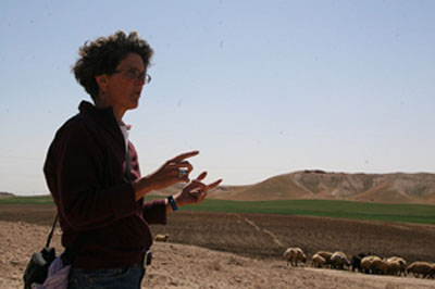
Augusta McMahon at Tell Brak
The growth and sustainability of the early city during the late 5th
–early 4th millennium BC have been the major foci of the most recent
research, under the Field Direction of Augusta McMahon. Late 4th-early
5th millennium BC socio-economic complexity is reflected in industrial
activities in the lowest levels of Area TW. We have also exposed four
unique mass graves of the early 4th millennium BC within one of the
small mounds defining the limits of Brak's Outer Town (Tell Majnuna).
These graves, the result of violent conflict or early warfare
contemporary with the intensification of urbanism at the site, reflect
the negative aspects of urbanism, including vertical hierarchies of
wealth and power and internal social stress. The graves were located in
a vast rubbish pile, testament to the logistic difficulties faced by
the city’s residents. Further excavations in Tell T2, a small mound at
Brak’s southeast edge, have revealed further industrial activities and
burials that reflect the shifting use of the peri-urban zone.
These recent excavations have also examined household archaeology
and cultural continuities and discontinuities across episodes of
environmental and political change from the terminal 3rd millennium
through the later 2nd millennium BC.
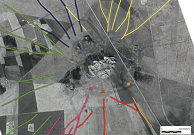
CORONA image of hollow ways by Jason Ur
Regional and Site Surveys
From 2002 to 2006, an intensive survey of the Brak Sustaining Area
(with a radius of 20 km from Brak) was undertaken, with Henry Wright as
Field Director. Based on satellite imagery and on-groudn sherd
collection, some 550 sites from Neolithic to Islamic date have been
identified and recorded.
An intensive field-walking survey of the immediate environs of Brak
itself (the Suburban Survey), carried out by Jason Ur and Philip
Karsgaard, has further extended our knowledge of the outer city at Brak
and its cycles of occupation from ‘Ubaid to early Islamic times.